

River biology
Why we monitor river biology
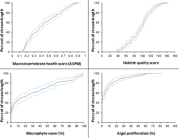
Waikato Regional Council monitors river biology to determine the ecological health of rivers and streams in the Waikato region. Fish tell us more about habitat and water quality, as well as about how well migratory native fish can get access to streams from the ocean. Invertebrates are a key part of the biodiversity of all rivers and streams. They also form an important part of the food chain in rivers and streams, and can influence habitat quality by filtering water, churning up sediments and breaking down organic material. Invertebrates are medium term indicators of stream health and integrate conditions over time prior to sampling. River biology is therefore less affected by small rainfall events than traditional water quality parameters such as faecal coliforms or E. coli which vary temporally in relation to rainfall.
Waikato Regional Council’s stream invertebrate monitoring programme:
- reports on the current condition of the state of the regions waterways as a per cent of waterway length in each condition class.
- determines ecological condition trends over time at long-term monitoring sites
- identifies environmental factors related to stream health
- helps develop policies that mitigate adverse effects on stream ecosystems
- provides information for assessing the effectiveness of restoration and mitigation activities
- helps achieve Waikato Regional Council’s responsibilities for state of the environment reporting
- helps assess the performance of policies in the Regional Policy Statement.
What's happening?
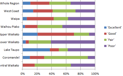
The invertebrate sampling shows us that ecological health of streams and rivers is better in some parts of the Waikato region than in others. This is mainly because of the greater intensity of land use in parts of the region with large areas of lowlands and developed hill-country.
Methods - how we monitor
Results - data and trends


Download the data file
The Excel spreadsheet below contains the source data to this indicator's graphs and any additional data.

More information
When this indicator is updated
This indicator is updated every three years
Footnotes
- Calculated for both hard-bottomed and soft-bottomed sites relative to hard-bottomed reference sites because there are few lowland soft-bottomed reference streams in the region. Further work is currently underway to determine the expected difference between reference site conditions for these two types of stream, and how this influences condition classes. We are also developing condition classes for habitat quality and algal and plant cover.
- Excludes algal-piercing Hydroptilidae.

To ask for help or report a problem, contact us
Tell us how we can improve the information on this page. (optional)