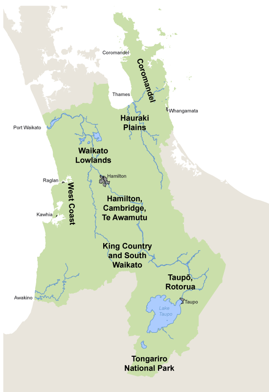
| Area |
Features |
Air quality issues |
| Coromandel Peninsula |
Sea breezes. Close to Auckland. Moderate population that greatly increases in summer. Low level of development. |
Smog from transport in Auckland reaches the Coromandel Peninsula, affecting visibility in fine conditions. Home fires and odours from industry affect air in localised areas. |
| Bombay Hills (southern side) |
Close to Auckland. Fog andinversion layers. Moderate population. Intensive horticulture with high use of agrichemicals. |
Smog from transport in Auckland affects visibility in fine conditions. Spray drift from agricultural activities can affect human health and nearby crops. Home fires and odours from industry affect air in localised areas. |
| Hauraki Plains |
Many calm periods and inversions. Moderate population density. Intensive agriculture, some isolated industry. Large areas of peat. |
Contaminants can build up when there is little wind and under inversion layers. In some towns home fires, vehicles and odours from industry affect air quality. Farming and other sources such as vehicles and peat fires can release greenhouse gases. Spray drift from agricultural activities can affect human health and nearby crops. |
| Waikato Lowlands |
Moderately exposed. Areas of moderate population and traffic, intensive agriculture and high stock numbers. |
The main effects in the Lowland Waikato area are odours and greenhouse gases mainly from intensive agriculture, and greenhouse gas emissions from home fires and vehicles. |
| Hamilton, Cambridge, Te Awamutu |
Some sheltered areas, many calm periods and inversion layers. High population density. Large industrial activity. Many domestic sources of contaminants and agricultural activities. Moderate traffic volume and congestion. Large areas of peat. |
Contaminants can build up when there is little wind and under inversion layers. Higher populations mean more home fires and more vehicles affecting visibility and health.
Odours from industry can make the air smell bad.
Methane and other greenhouse gases are released from farming, peat fires, and other sources such as vehicles. |
| West Coast |
Exposed to strong winds off the Tasman Sea. Varied landscapes. Very low population density. |
Air contaminants in the West Coast area are mostly from natural sources such as sea spray and dust. Other sources are occasional vegetation burning and agricultural spray drift. |
| King Country and South Waikato |
Cold, damp winters. Frequent inversion layers. Moderate population and traffic. Large quantities of air contaminants from industry. |
Microclimates (climates specific to an area) in some areas cause the build–up of contaminants under inversion layers. Air contaminants and odours are released from home fires, backyard burning and local industries. |
| Taupo, Rotorua
|
Moderate winds. Geothermal areas. Moderate population density. |
Geothermal areas release odours and gaseous contaminants such as hydrogen sulphide, which smells like rotten eggs. Home fires release very small particles that can reduce visibility and affect human health. |
| Tongariro National Park |
Exposed sites, high winds. Low population density. Potentially sensitive ecosystem. |
There are few effects from local sources, but potential for volcanic and geothermal eruptions that can affect air quality over a large area. Volcanic and geothermal emissions can affect local ground air quality releasing gases such as hydrogen sulphide which smells like rotten eggs. |


To ask for help or report a problem, contact us
Tell us how we can improve the information on this page. (optional)