

Earthquakes
Visit the Waikato Regional Hazards Portal to check out an interactive map of earthquake faults and liquefaction mapping in the Waikato region.
What causes earthquakes?
Earthquakes occur when tectonic plates grind and scrape against each other, or when there's a sudden slip on a fault (a break in the earth’s crust). A fault slip is caused when stress (pressure) builds up and the rocks slip suddenly, releasing energy in waves that travel through the earth's crust. These waves cause the shaking that we feel during an earthquake.
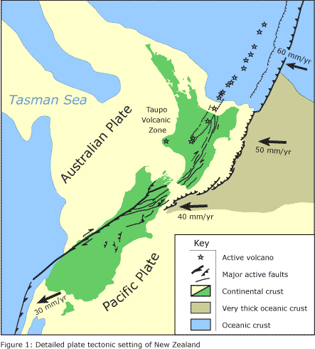
Earthquakes are relatively common in New Zealand because we are located on the boundary of two of the world’s major tectonic plates – the Pacific Plate and the Australian Plate. These plates are moving towards each other by about 50 mm per year.
Climate change is not expected to affect the occurrence of earthquakes. However, the impacts of an earthquake will be greater if communities are already under stress from climate change-exacerbated events such as drought and flooding.
Earthquake hazard in the Waikato region
The Waikato region is generally considered to be less hazardous for earthquakes than much of New Zealand, as shown in the National Seismic Hazard Model. However, there are still many known faults that could cause significant damage, as well as faults still under investigation, such as those close to Hamilton. Also, the Waikato could experience ground shaking from faults outside of the region, such as the Hikurangi Subduction Zone (off the east coast of New Zealand).
There are three large active faults considered 'risky' in the Waikato region:
- The Kerepehi Fault - extending along the Firth of Thames and the Hauraki Plains.
- The Rangipo Fault - on the eastern side of Mount Ruapehu.
- The Wairoa North Fault - running along the Bombay Hills north-east of Mercer.
The area between Taupo and Rotorua is the most vulnerable part of our region for earthquakes. It contains many active fault lines running in a north-east direction.
If an earthquake occurs, the amount of shaking felt in areas of the Waikato region will depend on many things, such as the size of the earthquake, the distance from the epicentre, and the geology of the area. Our ground shaking susceptibility map (linked to from the Waikato Regional Hazards Portal) uses the classification of geological materials to indicate the relative level of ground shaking likely to be experienced if an earthquake occurs.
Earthquake hazards
The type of hazards that result from an earthquake depend on the strength of seismic activity, along with factors such as local topographic and built features, geology and groundwater. A large earthquake will always be followed by a sequence of aftershocks – generally larger earthquakes produce larger and more aftershocks than smaller ones.
The primary hazards caused by earthquakes are ground shaking and fault rupture:
- Ground shaking – Strong ground shaking can damage structures such as buildings, bridges and roads, and can destabilise cliffs and sloping ground. Perched or stacked objects may fall and injure or bury anyone close by. Ground shaking will vary over an area due to factors such as topography, geology, and the location and orientation of the fault rupture, which affect the way the seismic waves travel through the ground.
- Fault rupture – In a major earthquake the ground surface may rupture along a fault line, meaning anything above the fault rupture, such as a building, is likely to be damaged.
Ground shaking and fault rupture may result in any of the following secondary earthquake hazards:
- Landslides and rockfall – Ground shaking can destabilise cliffs and steep slopes, causing landslides and rockfalls. Heavy rain or pre-existing weak rock can exacerbate this.
- Liquefaction - Liquefaction causes soil to behave more like a liquid than a solid during an earthquake. Ground shaking rearranges sand and silt grains in wet soil underground and the water between the grains is squeezed. Pressure builds up until the grains float and water is forced up to the surface, often through cracks in the ground or concrete. The rising water takes silt and sand with it, forming sand boils or volcanos. The ground surface above liquefied soil often tilts and sinks, damaging buildings, roads, pipes and tanks. To liquefy, the soil must be loose, sandy or silty (clay and gravel tend not to liquefy) and wet (below the water table).
- Lateral spreading - Lateral spreading occurs where sloping ground starts to move downhill, causing cracks to open up, that are often seen along hill crests and river banks.
- Subsidence - Subsidence can occur as a result of fault movement or liquefaction, and can result in permanent flooding of areas.
- Tsunami - Long wavelength oceanic waves generated by the sudden displacement of seawater by a shallow earthquake (or volcanic eruption or landslide).
Liquefaction
Liquefaction is a natural process where earthquake shaking increases the water pressure in the ground in some types of soil resulting in temporary loss of soil strength. Liquefaction can cause significant damage to land, buildings, infrastructure and the environment, as well as economic and social disruption.
The three key factors which influence whether liquefaction occurs and the severity of the resulting ground damage are; soil condition (material type and density), groundwater table depth and earthquake shaking (duration and intensity).
Figure: Soil liquefaction process (source: Building Performance NZ)
During the 2010-2011 Christchurch earthquakes, Christchurch experienced significant liquefaction. Since the earthquakes, a lot of information has been collected about the city’s ground conditions, and Christchurch City was one of the first in New Zealand to map its liquefaction vulnerability. The assessment done in Christchurch included new vulnerability categories that have now been introduced nationwide.
Level A Liquefaction Mapping for the Waikato region
The November 2019 Building Code Update has revised B1/AS1 to ensure new buildings are built safe and strong enough to withstand liquefaction effects. To help district councils within the Waikato region, we have done a liquefaction hazard assessment to provide Level A liquefaction mapping for the whole region. The purpose of this work is to inform a liquefaction vulnerability assessment based on the Planning and engineering guidance for potentially liquefaction-prone land (MBIE, MfE, EQC)
The new hazard maps can be viewed on the Waikato Regional Hazards Portal.

To ask for help or report a problem, contact us
Tell us how we can improve the information on this page. (optional)