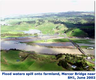
River flooding
View river flood modelling and other spatial information relating to river flooding.
Flooding in our region
River flooding is a frequent event in the Waikato region, because:
- it is susceptible to storms of tropical origin
- many steep river catchments get intense, localised rainfall that is also difficult to predict
- it has large river systems
- it has large areas of low-lying flood plains near sea-level that are intensely farmed or developed
- large areas of land lack vegetation cover, increasing run-off and erosion.
River flooding is more likely to occur when:
- heavy rain runs off already saturated soils
- a river channel is no longer able to hold the volume of water
- damaged or poorly constructed stop banks fail to hold floodwaters back
- drains (such as storm water drains) are blocked by debris
- there is a high tide or king tide, increasing water levels in rivers that flow into the sea.
As a result of the projected effects of climate change, more heavy rainfall will increase the risk of inland flooding in the west and in river catchments in the Coromandel. Increased sea levels (due to sea level rise) will also increase the risk of river flooding in rivers that are influenced by sea level, such as those that drain to the sea.
Main flood hazard areas
- Coromandel - due to its short steep catchments (where rain quickly runs into the rivers) and susceptibility to tropical storms. The Coromandel has frequent severe flooding when water levels rise very quickly, with little time for warning and preparation.
- Hauraki Plains - low lying farmland and towns are vulnerable to flooding along the Waihou and Piako river systems.
- Farmland adjacent to the Waipa River – vulnerable to flooding, especially since the river is uncontrolled by dams.
- Lower Waikato River (from Ngaruawahia north) - properties on low lying land near the Waikato River are at risk. The River carries large volumes of water where the Waipa River joins the Waikato River.
- Flooding at the southern end of Lake Taupo - where the Tongariro and Tauranga-Taupo rivers enter the Lake.
Managing the risk
There are many ways that Waikato Regional Council works to avoid or reduce the impact of flooding.
- Education of stakeholders, including the public.
- Sensible planning by locating development away from flood pathways.
- Early warning of flood events to allow mitigation actions to be taken.
- Stopbanks - which keep water within the channel.
- Control structures - such as flood gates, which divert water to be held until it can be released when water levels fall and pumps which pump ponded water back over the stopbanks.
- Dams on the Waikato River - which allow flood peaks to be held back so they don’t coincide with the Waipa River peak flow where the two rivers join at Ngaruawahia.
- Catchment management - through planting, soil conservation and pest control.
- Land drainage - which helps keep the water table low.
More information on WRC’s river and catchment management work, including flood protection and land drainage, is available on the Integrated catchment management page and at Come High Water.
Regional flood warning system
Waikato Regional Council operates a flood warning system, using automated alerts activated by heavy rainfall and rising river levels.
Waikato Regional Council uses the flood warning system to:
- monitor river and rainfall levels at over 50 automated recording sites
- warn landowners and communities about flood risks
- coordinate flood response
- collect data to improve our accuracy of flood prediction
- maintain our flood protection assets, such as stopbanks and pump stations.

You can sign up for our flood warning service. Either
- send us a message to request sign up or
- call 0800 800 401 and ask for the Emergency Management Officer (EMO).
River flood modelling is used to provide detailed information on the flood hazard of a river or stream. Click here for more information.


To ask for help or report a problem, contact us
Tell us how we can improve the information on this page. (optional)