Estuarine Vegetation Survey: Whangamata Harbour and Otahu Estuary
Report: TR 2007/25
Author: Meg Graeme (Natural Solutions - Marine and Terrestrial Ecologists Ltd.)
Abstract
A 1997 pilot study of Whangamata, Wharekawa, and Otahu estuaries determined that it is feasible to map vascular estuarine vegetation from aerial photography together with field surveys. The success of this work encouraged Environment Waikato to continue with this method. The estuarine vegetation of Tairua, Coromandel, Te Kouma, Manaia and Whitianga estuaries were mapped in 1998 and 1999. Port Waikato, Raglan, Aotea, Kawhia estuaries and the inner Firth of Thames have recently been mapped between 2004 and 2006.
The vegetation that has been mapped is in the Coastal Marine Area (CMA) and includes the spatial cover of mangrove, seagrass, sea meadow, and saltmarsh communities. The results of the estuarine surveys are included in Environment Waikato’s Global Information System (GIS) database, and are used for State of the Environment investigations and assessing consent applications that may affect estuarine vegetation.
This report details the results from a survey of estuarine vegetation in the Whangamata Harbour and Otahu Estuary. These are the first estuaries to be re-surveyed using this methodology. Comments are included on the threats to estuarine vegetation, and other field notes of interest.
Estuarine Vegetation Survey : Whangamata Harbour and Otahu Estuary [PDF, 1.7 MB]
Estuary Vegetation Otahu map

Click on highlighted areas on this map for a zoomed in view.
Estuary Vegetation Whangamata map
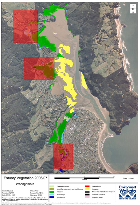
Click on highlighted areas on this map for a zoomed in view.
| Contents | ||
| 1 | Introduction | 1 |
| 2 | Methodology | 1 |
| 2.1 | Wetland vegetation classification | 1 |
| 2.1.1 | Saltmarsh | 1 |
| 2.1.2 | Mangrove | 2 |
| 2.1.3 | Seagrass | 2 |
| 2.1.4 | ‘Weed community’ | 2 |
| 3 | Field notes | 2 |
| 3.1 | Summary | 2 |
| 3.2 | Site descriptions | 4 |
| 4 | Discussion | 56 |
| 4.1 | Whangamata Harbour | 56 |
| 4.2 | Otahu Estuary | 56 |
| 4.3 | Recommended action points / restoration projects | 57 |
| 5 | References | 59 |
| 6 | Appendices | 60 |