

Hipaua steaming cliffs
The Hipaua steaming cliffs are part of an active geothermal field South of Lake Taupō. The cliffs area has been the source of several devastating landslides in the past and is a continuing threat to people and property.
The Hipaua geothermal area forms part of the Tokaanu-Waihi Geothermal Field (TWGF), South of Lake Taupō. This area is recognised for the catastrophic and deadly landslides that occurred in 1846 and 1910.
More recently, in 2009, observed environmental changes prompted concerns that a major landslide could occur above Waihi village. Residents observed a significant change inflow of the Waimatai and Omoho Streams, and sounds of rockfall accompanied by ground vibrations significant enough to cause birds to take flight and to unsettle dogs and horses. On that occasion, the Waihi community self-evacuated.
The 2009 event resulted in a GeoNet Landslide Response. The outcome of the investigation was that there was no clear evidence that a major movement occurred. The event also triggered an investigation by GNS Science, which included the implementation of a GNSS (Global Navigation Satellite System) monitoring network.
The Hipaua landslide area remains a significant threat to the immediate area and wider community including but not limited to:
- Waihi Village residents and significant Historical cultural sites
- Braxmere Lodge
- Tokaanu residents and adjacent entities
- Lake Taupō foreshore and lakebed
- Lake Taupō (tsunami risk)
- SH41 users (Over 1,700 vehicles a day use)
For more information, you can view a copy of the ‘Tephra’ article, ‘Hipaua Steaming Cliffs and Little Waihi Landslide’ on the National Emergency Management Agency’s website.
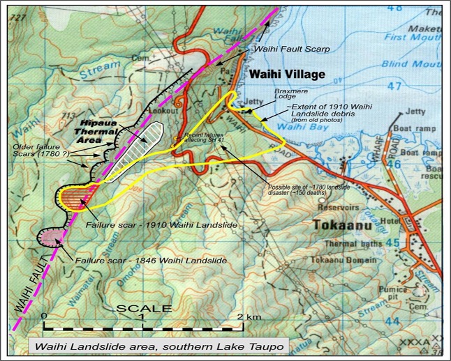 Figure: Map of the Hipaua area (source: GNS Science)
Ongoing risk management
- We work with the Taupo District Council emergency management team and Iwi to monitor the area, identify risks and develop community-based contingency plans.
- Every 1-2 years, in partnership with Taupo District Council, Waka Kotahi (NZTA) and Transpower, we commission consultants’ reports to survey the hazard area. The last survey of the deformation network (GNSS) was done in 2021 by GNS Science.

To ask for help or report a problem, contact us
Tell us how we can improve the information on this page. (optional)