

Why we monitor indigenous coverage of protected areas on land
The Waikato Regional Policy Statement has a policy to provide for (among other things) the promotion of voluntary legal protection, restoration or enhancement of indigenous biodiversity.
Terrestrial indigenous vegetation formerly covered most of the Waikato region, providing vital habitat for indigenous plants and animals. Clearance of indigenous vegetation, along with fragmentation and introduction of alien species, is considered one of the main causes of indigenous biodiversity decline. Legal protection in a gazetted reserve or other legal instrument is one method to protect indigenous habitat and biodiversity from deliberate destruction.
Maintaining a network of protected indigenous land cover is a core strategy in protecting biodiversity and the environment. Protected areas designated for the purpose of conserving biodiversity are set aside to maintain functioning natural ecosystems, to provide a refuge for species, and to maintain ecological processes that cannot otherwise be maintained in most of our intensely managed landscapes. Long-term or permanent legal protection of indigenous land cover, coupled with effective management, is therefore an important tool for the conservation of indigenous biodiversity.
In New Zealand, legally protected indigenous land cover can be on publicly or privately owned land, and include:
- Department of Conservation reserves
- Ngā Whenua Rāhui Kawenata (protected Māori-owned land)
- QEII covenants (private protected land)
- other areas protected by territorial authorities or state-owned land.
Some land is legally protected for the express purpose of protecting natural features from deliberate destruction/ development. In other cases, land has been set aside for another purpose such as for recreation or future use for cemeteries, road widening or other public amenities. If such land has been gazetted under the Reserves Act, there is a secondary requirement to protect natural features in that parcel, to the extent compatible with the reserve’s stated purpose.
Waikato Regional Council has analysed the extent of indigenous vegetation on land (dryland forest, scrub, tussock, fernland or lightly vegetated indigenous land cover) in the region that is in a form of legal protection (for example gazetted as a reserve or identified as an open space covenant on land title). We also analyse protection of the region's Nationally Threatened Environments (TEC) and calculate the indigenous coverage of our unprotected areas.
Monitoring trends in the type, location, and extent of protected areas gives us valuable information on how much protection we are giving to our region's unique biodiversity and whether our protected indigenous land cover network contains the full range of natural ecosystems in the region.
Monitoring protected natural ecosystems on land helps us to:
- assess overall progress of total area protected as a measure of policy response to biodiversity loss.
- track changes in extent of protected areas in relation to geographical and political units, and to different measures of biodiversity (such as priority areas, ecosystem or habitat maps and species distributions)
- ensure a full range of habitats are protected to ensure that biodiversity is preserved
- find out what geographic areas are under-represented in the current reserves system
- identify priority areas for conservation, including opportunities to provide for landward, southward, or altitudinal migration of species or ecosystems in response to changes in sea level or temperature induced by climate change, and to improve connectivity of fragmented landscapes and seascape.
The monitoring outcomes can therefore guide adaptive management and policy decisions for biodiversity management planning.
What's happening?
Waikato Regional Council monitors changes in the amount and proportions of indigenous vegetation and lightly vegetated or un-vegetated natural land cover that is in some form of legal protection, including government reserves and private protected land.
Our indicator reports on what land cover types are protected, who is protecting it, and where it is protected. It also reports on 5-yearly changes in the extent of vegetation and natural land cover that is under some form of legal protection, and the proportion of land protected in each Threatened Environment.
This indicator shows that:
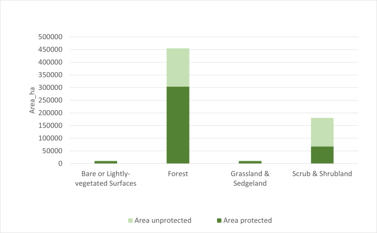
- As of March 2022, around 17 per cent of the Waikato region is in some form of legal protection. Most of that is in natural cover, mainly indigenous forest (71 per cent of all protected land), followed by scrub and shrubland (16 per cent), with bare or lightly vegetated land and indigenous sedgeland or grassland each contributing just 2 per cent. The remaining 9 per cent is built land (e.g. car parks), wetland or water, or non-indigenous cover such as grass or exotic trees.
- Reserves and covenants protect 59 per cent of the region’s remaining indigenous land cover. Bare or lightly vegetated surfaces, and indigenous tussock sedgeland or grassland are relatively well protected, with over 80 per cent of region’s current extent in protection. Of our remaining extent of indigenous forest, 67 per is legally protected, while just 37 per cent of the remaining areas of scrub and shrublands are protected.
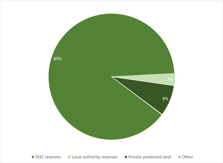
- The Department of Conservation (DOC) owns or administers 89 per cent of the protected natural land cover, while 8 per cent is on private land and the rest is in district or regional council reserves. Relatively little indigenous land cover is protected in district council reserves, however this amount may be an under-estimate as data on district council reserves is less complete than for DOC or covenant data.
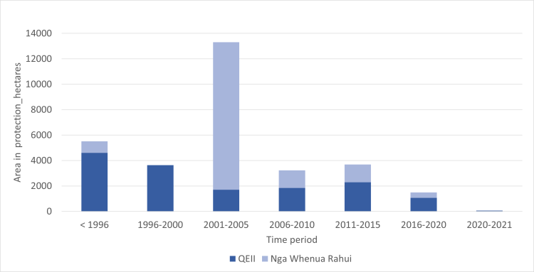
- Private landowners have been protecting indigenous land cover in QEII Open space covenants in the Waikato region since 1979. Between 1996 and 1 January 2022, the amount of land in QEII covenants in the region increased from 4,607 to 15,234 hectares, an average rate of 425 hectares per year.
- Ngā Whenua Rāhui kawenata (NWRK) offer 25-year term renewable covenants over Māori land. The first kawenata in the Waikato region was registered in 1993. Between 1996 and 2022 the amount of land protected by NWRK in the region increased from 903 to 15,695 hectares, an average rate of 592 hectares per year. That rate has slowed in recent times (since 2005 for QEII and since 2010 for kawenata).
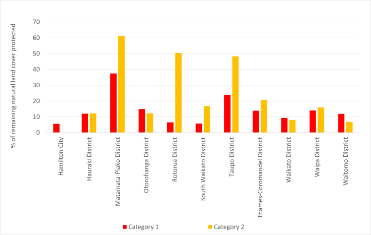
- Over 46,000 hectares of terrestrial indigenous cover remains unprotected in our most depleted land environments (Category 1 and 2 Threatened Environments).
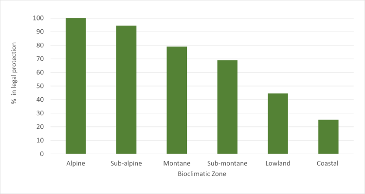
- In alpine and sub-alpine areas, almost all of the remaining indigenous land cover is protected, while in montane and submontane areas over 69 per cent of the remaining indigenous cover is protected. Indigenous vegetation in coastal and lowland areas have the least amount of protection, (25 per cent and 45 per cent respectively).
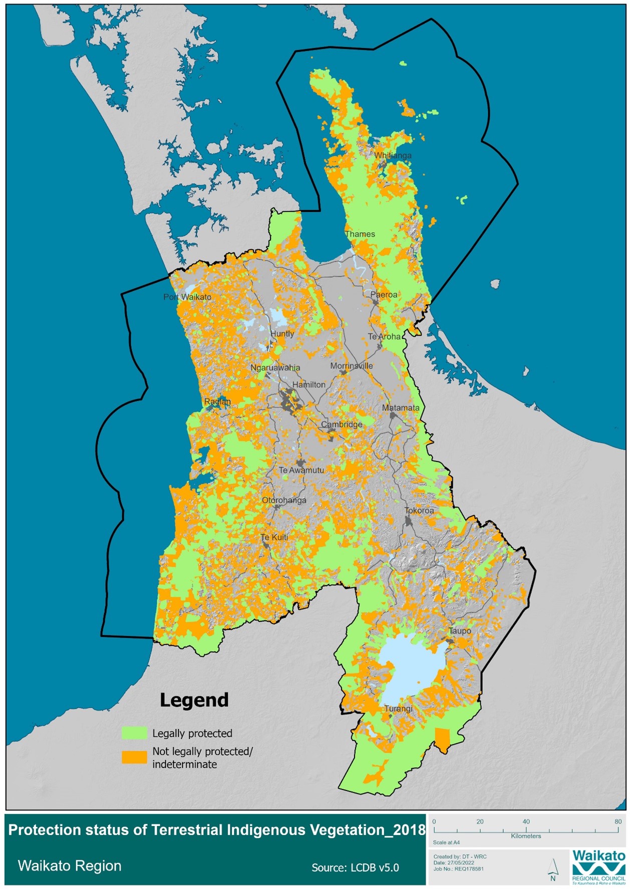
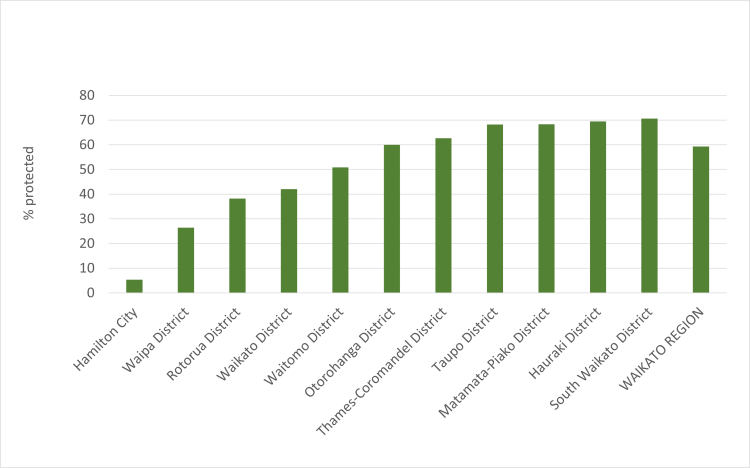
- Within the district council areas, Thames-Coromandel District has the highest proportion of land in some form of protection (41 per cent of the district is legally protected), while Hamilton City and Waipā District have the least amount of their total land area in protection (1 and 3 per cent respectively). Of the amount of terrestrial indigenous cover remaining in each district, 71 per cent is protected in South Waikato District, and over 50 per cent in each of Waitomo, Taupō, Thames-Coromandel, Ōtorohanga, Matamata Piako, and Hauraki districts.
Methods - how we monitor
Results - data and trends
Download the data file
The Excel spreadsheet below contains the source data for this indicator's graph and information.

More information
Copyright
Information obtained from Statistics New Zealand may be freely used, reproduced, or quoted unless otherwise specified. In all cases Statistics New Zealand must be acknowledged as the source.
Related publications
Ministry for the Environment & Department of Conservation. 2007. National Priorities for Protecting Rare and Threatened Native Biodiversity on Land. New Zealand Government, Wellington. https://www.doc.govt.nz/about-us/our-policies-and-plans/biodiversity-guidance-for-private-land
Related links
Les Molloy. Protected areas - Specially protected areas, in Te Ara - the Encyclopaedia of New Zealand. http://www.teara.govt.nz/en/protected-areas
Protected areas of New Zealand http://en.wikipedia.org/wiki/Protected_areas_of_New_Zealand
Ministry for the Environment: Legally protected conservation land in New Zealand. https://environment.govt.nz/publications/a-snapshot-of-council-effort-to-address-indigenous-biodiversity-on-private-land-a-report-back-to-councils/legally-protected-areas-for-indigenous-biodiversity/#:~:text=Of%20New%20Zealand's%20total%20area,of%20New%20Zealand's%20total%20area
Department of Conservation legal protection
http://www.doc.govt.nz/about-us/science-publications/conservation-publications/protecting-and-restoring-our-natural-heritage-a-practical-guide/legal-protection/
DOC’s Public Conservation Lands (PCL) GIS layer available on Koordinates http://koordinates.com/layer/754-doc-public-conservation-areas/
QEII National Trust http://www.openspace.org.nz/
Ngā Whenua Rāhui http://www.doc.govt.nz/nwrfund
CoreLogic – property information http://www.corelogic.co.nz/
Land Environments of New Zealand (LENZ) - http://www.landcareresearch.co.nz/resources/maps-satellites/lenz
Interactive map of Threatened Environments
http://www.landcareresearch.co.nz/resources/maps-satellites/threatened-environment-classification/ourenvironment
Maps of National Priority Environments
http://www.mfe.govt.nz/more/biodiversity/national-policy-statement-biodiversity/statement-national-priorities-biodiversity
Biodiversity Indicators Partnership - A global initiative to promote and coordinate the development and delivery of biodiversity indicators for use by the Convention on Biological Diversity (CBD) and other biodiversity-related conventions. www.bipindicators.ne
When this indicator is updated
Updates will happen as new (region-wide) vegetation/cover spatial layers become available. It is estimated that this will be updated every 5 years.
Last updated: September 2022

To ask for help or report a problem, contact us
Tell us how we can improve the information on this page. (optional)