

Soil quality
Why we monitor soil quality
Waikato Regional Council monitors soil quality to provide information about how particular land uses are affecting soils in the long-term. Some land uses and land management practices may affect soil properties and reduce soil quality over time.
Some reductions in soil quality, such as lost organic matter, can take many decades to remedy. This can mean that future landowners are unable to grow crops or pasture of the same quality or need to use greater amounts of fertiliser to achieve the same result as previously.
The better the measured soil characteristic matches the guideline value for its current land use, the better the soil quality. Scores for individual soil quality characteristics are grouped together for each land use to give the percentage of sites in the Waikato region that meet (or fail to meet) soil quality guidelines. This is expressed as satisfactory soil quality and soil quality that is ‘of concern’.
We can get an idea of what the soil quality issues are for certain land uses by looking at which key soil quality characteristics don’t meet guideline values for that land use. For example, fertility imbalance and soil compaction are currently the main concerns identified for pastoral farming soils.
What's happening?
Good quality soils are those where key soil characteristics are in good condition for the current land use. We want soils to hold water and nutrients where they are readily available for plant roots to take them up, suppress pests and weeds, sequester carbon from the atmosphere, filter clean the water that flows through it into rivers, lakes, and aquifers, and prevent flooding by acting as a sponge during heavy rain. Good quality soils are full of beneficial organisms from microbes to earthworms that have important roles in natural recycling, inhibiting disease-causing organisms and soil formation (especially soil organic matter).
Waikato Regional Council measures soil quality for four main land use types in the Waikato region:
- dairy farming
- drystock farming (sheep, beef, deer etc.)
- horticulture and cropping
- plantation forestry.
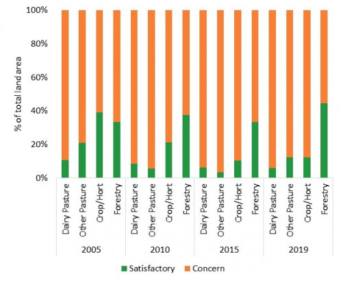
About 15 percent of productive sites across the region had satisfactory soil quality for their current land use in 2019. This compares with 18 percent being satisfactory in 2010 and 43 per cent in 2005.
About 94 percent of sites under dairy farming had soil quality that is of concern, with excessively high fertility and/or soil compaction affecting about 85 percent of the sites.
Similarly, more than 88 percent of sites under drystock farming had soil quality that is of concern. About 70 percent of the sites are affected by soil compaction and/or excessive fertility, while about 24 percent of sites are affected by low fertility.
Nearly 90 percent of sites under cropping and horticulture has soil quality that is of concern. About 70 percent of the sites are affected by excessively high fertility while about 55 percent of the sites under cropping have low stability of aggregates. Nearly all cropping sites show loss of soil organic matter compared to other land uses.
About 58 percent of the land under forestry has soil quality measurements outside targets. Around 35 percent of sites are considered ‘loose’. ‘Loose’ is the opposite of compact and many of the region's soils are naturally loose. Loose soils are more prone to erosion. Trees reduce the risk of erosion. They protect the ground surface from the impact of rain, dry out wet soil by transpiring large amount s of water and bind earth with their roots. So the forestry land use allows production on what would otherwise be unproductive land. However, care is needed at harvest or conversion to another use where the land is made bare of vegetation. Conversely, sites where logging occurred showed evidence of disturbance and compaction from dragging logs and machinery.
How we monitor
Data and trends
Download the data file
The Excel spreadsheet below contains the source data for this indicator's graph and information.
The graph shows the percentage of sites meeting guidelines for satisfactory soil quality and soil quality ‘of concern’, by land use type.
The data were collected between 1996 and 2019.

When this indicator is updated
The indicator is updated annually.

To ask for help or report a problem, contact us
Tell us how we can improve the information on this page. (optional)