


About the Raglan/Whāingaroa catchments
The catchments of Whāingaroa Harbour cover approximately 52,595 hectares of land along the west coast of the North Island. The Whāingaroa catchment includes 826 kilometres of streams and has been split into five sub-catchments for management purposes: Kerikeri, Waingaro, Ohautira, Waitetuna and Opoturu.
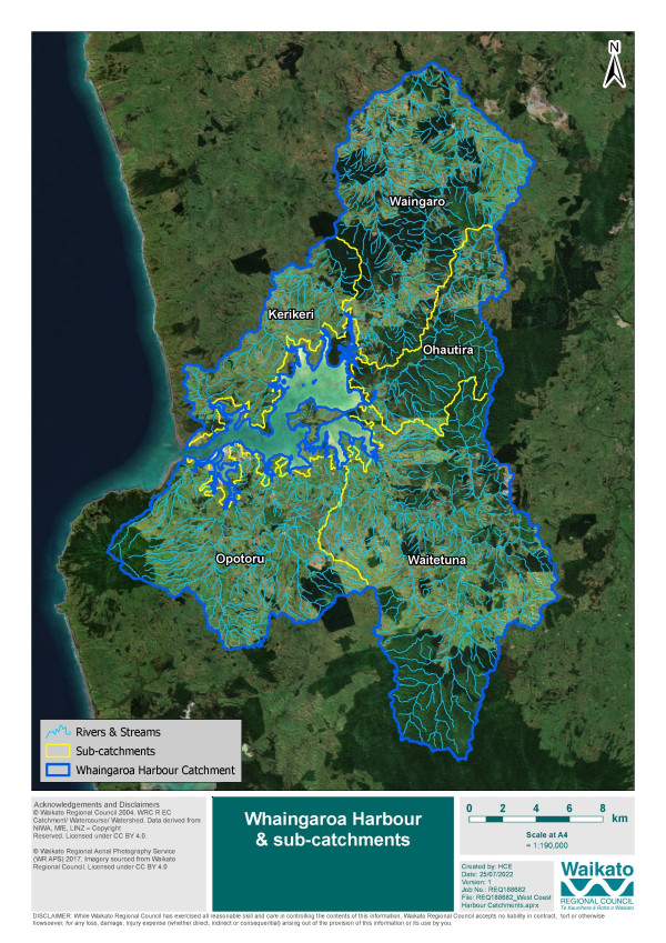
Whāingaroa is the second largest of the three harbours on the west coast, covering an area of 3185 hectares with 133 kilometres of coast.
The Whāingaroa catchment has changed and developed over time particularly since human settlement. Removal of native vegetation has resulted in increased area of pasture for farming and as other catchment and land use activities increased there has been a change in sediment generation, decline in water quality and indigenous biodiversity and pest animals and plants have increased.
- 52,595ha of land
- 3185ha of harbour
- 70% harbour exposed at low tide
- 133km of coast
- 826km of streams
How to get involved
We will be talking to partners, agencies, iwi representatives, rural landowners and local communities to understand their concerns, aspirations and ideas for the harbours and their catchments. You and your community can help to determine the focus of this work, and it may include areas such as water quality, sedimentation, biodiversity, riparian vegetation, pest plants and animals, flood-prone areas and preserving local values.
If you have any questions, please telephone Catchment Planning Advisor Amy Taylor on 07 859 0792 or email amy.taylor@waikatoregion.govt.nz.
Watch this short video from Re:News, How A Town Saved It's Harbour
Credit: Whāingaroa Harbour Care

To ask for help or report a problem, contact us
Tell us how we can improve the information on this page. (optional)