Over time, freshwater farm plans are expected to become the central tool for farmers and growers to manage all their fresh water regulatory requirements. Head back to the fresh water farm plan area to answer any questions you may have.
-
Introduction
Information to consider in your freshwater farm plan for the Waipā Freshwater Management Unit.
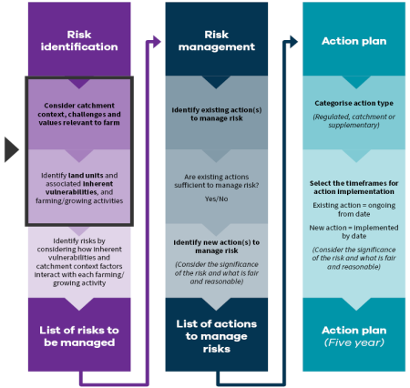
Catchment context, challenges and values (CCCV) is about linking your farming or growing operation to your wider catchment.
The information supplied here will help you to understand the unique environmental features, current environmental health status, cultural values and practices, and important recreational sites of your catchment, when developing your freshwater farm plan (FWFP).
You will need this information to consider how your farm’s natural landscape and farming and growing activities impact the health of fresh water and freshwater ecosystems in your catchment.
You will also need this information to help identify how best you will manage or reduce those impacts to protect the health of your catchment for future generations.
It is important to consider this whole-of-catchment information in your FWFP because individual actions contribute to the overall state of the Waipā freshwater management unit or catchment.
CCCV
Why do I need this information?
How to use CCCV
Overview
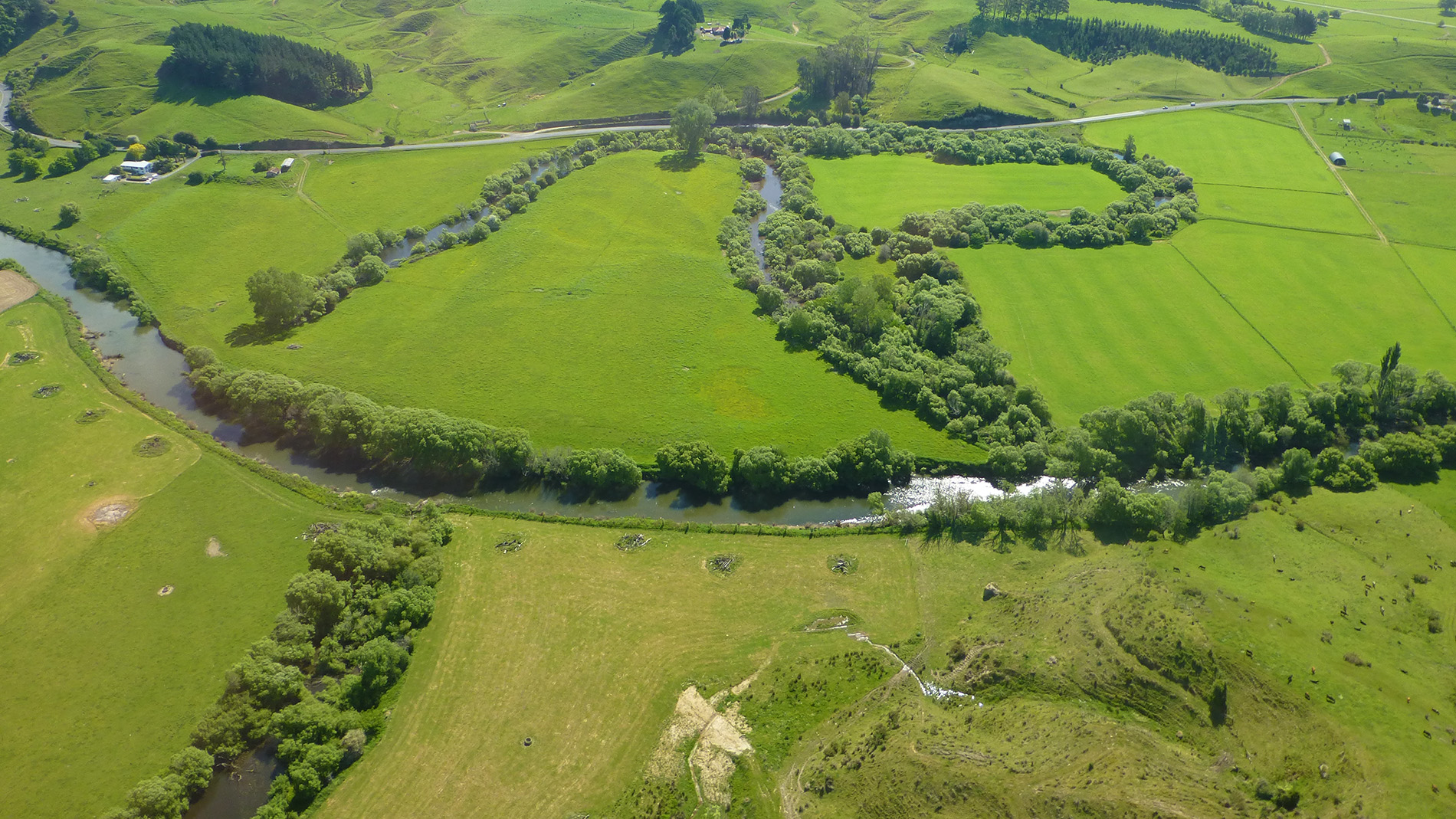
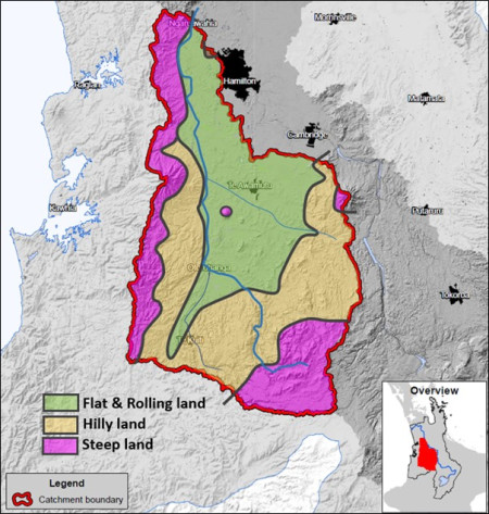
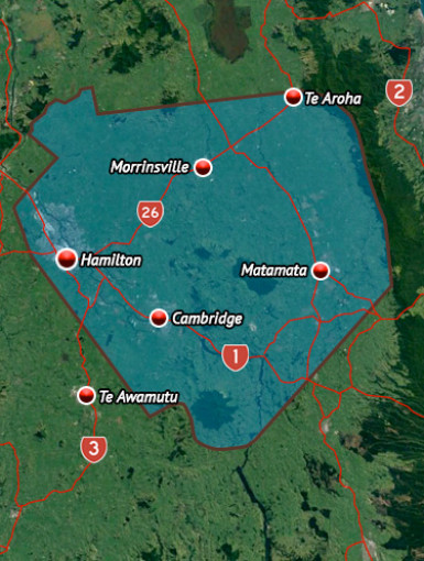
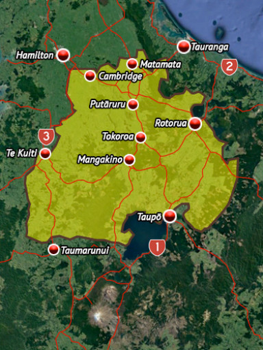
The Waipā freshwater management unit (FMU), or catchment, covers 306,569 hectares and is dominated by the Waipā River and associated tributaries. The Waipā River is the single largest tributary of the Waikato River. The awa (river) starts at the Pekepeke wetland close to the Rangitoto Range in the southern King Country, southeast of Te Kūiti. From there, it flows through land that was once native bush, wetlands and peat bogs, but is now mostly farmland and steep hill country. Steep, erosion-prone hillsides in several sub-catchments and soils with areas of instability deliver high loads of sediment to some tributaries and the main channel of the Waipā River, making it murky brown in colour. It flows northwards through rolling lowland areas to the towns and villages of Ōtorohanga, Pirongia and Whatawhata, before meeting the Waikato River at its confluence in Ngāruawāhia, 115 kilometres from its headwaters in Pekepeke.
Since the 1840s, most of the native vegetation in the catchment’s low-lying valleys and flood plains have been converted to pasture for agricultural purposes. This includes almost all the significant wetland areas, which have been drained, leaving behind only remnant pockets of wetlands and shallow peat lakes. Much of the catchment’s steeper hill country has also been converted to pasture to support drystock farming.
The catchment's boundaries are flanked on the western, eastern and southern sides by high rolling and steep hills. As a result, a basin has formed, consisting of lower rolling to flat land which is drained by/drains into the Waipā River.
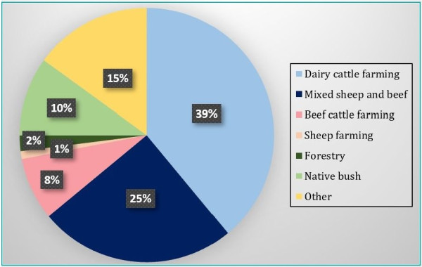
The Waipā FMU covers 28 per cent of the total Waikato River catchment and is divided into 20 sub-catchments. It contains 4825 kilometres of mapped stream and river channels, about 11 per cent of the total length of waterways within the Waikato region. Almost three-quarters of this stream length consists of small first and second order channels draining primarily pastoral land used for dairy, beef, and sheep farming.
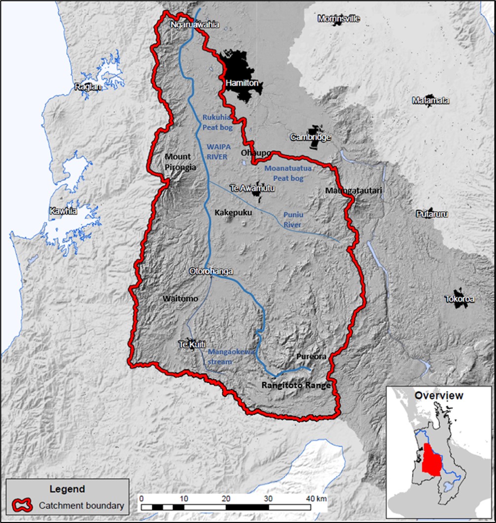
Figure 1. The Waipā catchment/FMU in relationship to the Waikato region.
Fresh water
What do I need to consider?
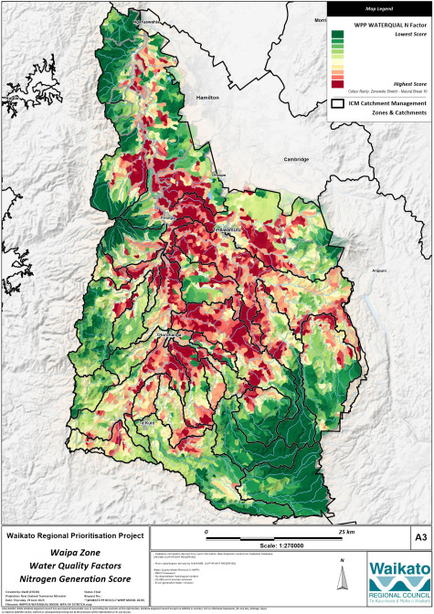
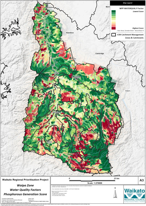
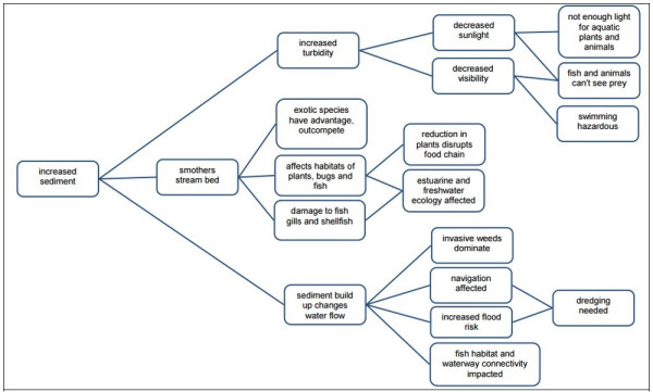
Water quality – due to nitrogen, phosphorus, E. coli and sediment loading – declines from the upper reaches to the lower reaches of a catchment, so the location of your farm should be the focus of your risk assessment and guide the actions and priorities of your FWFP.
Context and challenges
In general, water quality is poor within the Waipā River, and the many shallow peat lakes found in the catchment also present declining water quality.
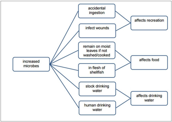
The water quality of the Waipā River is generally not good enough for swimming and does not support high ecological values. The river has high levels of E. coli bacteria and low clarity, mainly due to sediment. In the upper reaches of the Waipā River, the water quality is good enough for most aquatic plants and animals to be healthy.
The majority of nutrient and sediment inputs into the river are from diffuse sources. Factors such as sedimentation, nutrient runoff and land use intensification (from dry stock to dairy farming) negatively impact water quality. Urban intensification and non-agricultural sources also contribute to poor water quality within the catchment (Singleton 2017).
- Waikato Regional Council: Water quality monitoring map and data - all rivers and streams
- Statistics NZ river water quality: phosphorus
- Statistics NZ river water quality: escherichia coli
- Statistics NZ river water quality: nitrogen
- Statistics NZ river water quality: clarity and turbidity.
- NIWA: Waikato River Health and Wellbeing trends
- Waikato Regional Council: State of the Environment report
- Waikato regional Council: Water classification map
- New Zealand topographic map
Land |
What do I need to consider?
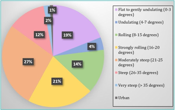
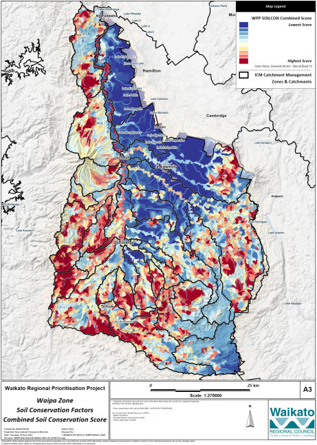
In developing your FWFP, you should be factoring in the physical features of the land with climate and your farming activities in order to assess the potential risk of contaminants impacting fresh water. Understanding the physical limitations of the land, such as soil type, climate and slope, is important. Knowing these limitations ensures land use is matched with LUC and appropriate management practices. For example, grazing of adult cattle on steep slopes with weak soils in winter can negatively impact soil structure and pasture production, or cause loss of topsoil. This can lead to erosion and sediment runoff impacting streams and/or wetlands.
Context
Soils |
What do I need to consider?
The location, properties and limitations of soils on your property form a significant part of the land unit identification, risk assessment and process of determining appropriate actions. For example, if your dairy effluent irrigation paddocks have very free-draining soils and are located on river flats next to a stream, the risk of nitrogen leaching is higher during times of high ground water. Your risk assessment will identify whether your current irrigation practices address this risk. If your current practices do not, then you would create actions to manage the risk so that impacts on freshwater quality are avoided or minimised as much as is possible.
Context and challenges
Climate |
What do I need to consider?
Climate is a major influencer of risks and impacts. When writing your FWPF, climate is one of the factors you should consider when defining your land units (areas of land with similar biosphere features) and their vulnerabilities.
High rainfall in areas dominated by weak bedrock and soils equals a high risk of erosion, slips, stock treading damage and runoff of contaminants to fresh water. Temperature impacts the growing of on farm feed, for example, whether you have good grass cover going into winter and the ability to leave adequate residuals to protect soils; or whether your paddock has been heavily grazed but still has the ability to grow grass and prevent runoff of sediment.
Context and challenges
Contaminants
What do I need to consider?
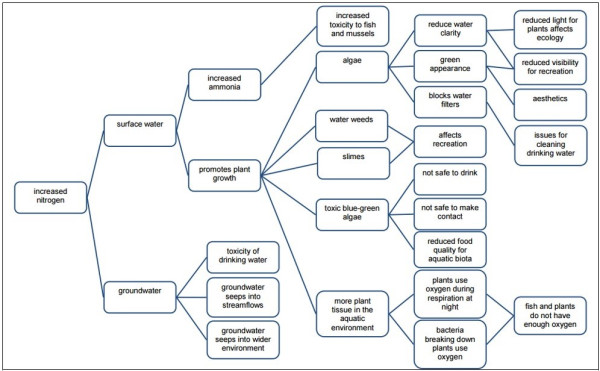
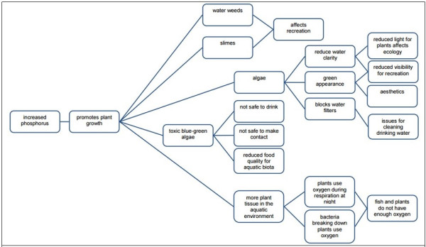
Contaminants are the biggest water quality issue facing the Waipā catchment. You should focus on reducing the risk of introducing nitrogen, phosphorus, sediment and E. coli to fresh water through your land management practices.
This will include:
- identifying where these contaminants are being generated
- taking into account exacerbating factors such as slope, soils and climate
- considering the impacts on community and cultural values.
Context and challenges
The four key contaminants identified as problematic to New Zealand waterways are nitrogen, phosphorus, sediment and E. coli (as a proxy for fecal contamination). All four contaminants can be attributed to point source and non-point (diffuse) sources.
The greater risk to water quality today is from non-point source discharges to land (Singleton 2017):
- nitrogen loss via leaching from the root zone of plants
- phosphorus and microbial pathogens via overland flow or artificial drainage
- sediment discharges from a combination of overland flows and riverbank and streambank erosion.
Point source discharges have been the subject of significant regulation and, over time, there has been a significant improvement in the way urban and industrial wastewater has been treated.
Freshwater habitat |
What do I need to consider?
Incorporating consideration of protecting and enhancing freshwater habitat and biodiversity on your farm can lead to better water quality outcomes and falls within the whole-of-farm or integrated farm planning approach. Actions to consider include:
- fencing off waterways, wetlands and remnants of native bush
- stabilising eroding streambanks
- planting and protection or creation of wetlands
- removing barriers to fish passage.
If your land drains into a peat lake, you should consider any potential impacts on the lake, in particular runoff of sediment and nutrients. Drainage can also be a source of contaminants and contribute to the loss of peat soils and the lowering of water levels within the lake and sounding wetlands.
Wetlands are very important. They are biodiversity hotspots and highly valued by the community for cultural and recreational reasons. They also offer a lot of potential to improve water quality before water leaves the farm. Even small, boggy seepage areas can reduce nitrogen, phosphorus, sediment and E. coli levels significantly. Protecting and enhancing or creating wetlands large and/or small should be considered a part of your FWFP to manage contaminants, improve habitat and reduce the environmental footprint of your farm or growing operation.
Context, challenges and values
The Waipā freshwater management unit contains a diverse range of indigenous ecosystems, including streams, rivers, lakes, wetlands, karst (limestone caves), forest and shrublands. In a healthy state, these ecosystems provide critical habitats for indigenous fauna, flora and micro-organisms. They also provide a range of fundamental ecological functions, such as acting as buffer zones for other ecosystems, reducing erosion and downstream sedimentation, nutrient storage and recycling, and the breakdown and absorption of pollutants. These ecosystem types (and associated aquatic flora and fauna) are at a very reduced state compared to the past.
A unique aspect of the catchment system is the lack of any major mainstem barriers to migratory fish passage. This, together with a relatively flat gradient, enables non-climbing migratory species such as common smelt and mullet to reach significant distances inland. However, it has also enabled access for numerous non-migratory invasive pest fish species, including koi carp, brown bullhead catfish and gambusia.
Recreational, commercial and customary harvest of trout, tuna/eels and kōura/crayfish is common in the wider system.
Tangata whenua |
What do I need to consider?
Tangata whenua have a deep and spiritual association with water, and these values need to be considered in your FWFP.
You should be looking for ways to protect and/or enhance sites of significance to tangata whenua on your property, such as wāhi tapu (cultural and spiritual) and wāhi tūpuna (landscapes and places) sites and areas of mahinga kai. For example, if there is a watercress gathering area or a community swimming hole in a stream that runs through your farm, then your FWFP must take those into account. It could be that you create actions to reduce sediment runoff from pugged paddocks or prevent the erosion of riverbanks by stock.
The New Zealand Archaeological Association maintains a website which is a good source of recorded sites of significance. District councils also provide information, including maps of recorded sites: Waitomo, Waikato, Waipā.
As not all sites of significance are recorded, you may also want to contact your local marae to enquire about sites relating to fresh water on your property, and for advice to help protect and enhance them. Visit Te Puni Kōkiri (Ministry of Māori Development) for contact information, or Te Kāhui Māngai and Māori Maps to find lists of representative groups for the iwi and hapū in your area.
Iwi environmental management plans are also a good starting point in terms of identifying any particular priorities iwi have for fresh water, particularly for specific catchments.
Iwi plans
Context and values
There are multiple iwi that have affiliations to the Waipā River. The iwi recognised on Te Kahui Mangai website are Waikato-Tainui, Maniapoto, Ngāti Hauā, Ngāti Korokī Kahukura and Raukawa. This handy mapping tool provided by Te Puni Kōkiri – Ministry of Māori Development provides a range of helpful information, including tribal rohe (areas), their hapū and marae, and representative organisations and contacts.
Iwi play an important part in the cultural, economic and political life of the region, advocating for Māori rights and preserving their rich cultural heritage for future generations. Iwi also play an important partnering and co-management role in the management of natural resources, including land, water and biodiversity. The Kīngitanga (Māori King Movement) is one of New Zealand’s most enduring political institutions and has broad support within the Waipā rohe.
In the context of fresh water, tangata whenua have a strong spiritual and cultural connection to rivers, lakes and streams, which are viewed as taonga (treasures) and sources of sustenance. Fresh water is regarded as a finite and precious resource that must be managed sustainably for the benefit of future generations.
Iwi recognise the importance of healthy freshwater ecosystems for the wellbeing of people and the environment, and advocate for the protection of water quality, the restoration of degraded waterways, and the recognition of Māori rights and interests in fresh water. Their freshwater values reflect a deep and holistic understanding of the importance of fresh water to tangata whenua. They recognise the interconnectedness between people, culture and the environment.
Iwi and the Crown have entered into co-management arrangements through three Waikato River Settlement Acts. These relate primarily to working relationships between the Crown, councils and iwi, the setting of policy and regional policy direction, and giving effect to Te Ture Whaimana o Te Awa o Waikato – the Vision and Strategy of the Waikato River.
For further information visit Waikato River and Waipā River co-management.
Iwi within the Waipā
Key concepts and definitions of tangata whenua
Statutory policies and plans
What do I need to consider?
The rules in the Waikato Regional Plan and the national regulations are the main things that you need to be aware of. Waikato Regional Council has developed the Farmers guide to environmental rules in the Waikato region, which is a very good source of information around all of these rules and is regularly kept up to date. If rules are relevant to your farming or growing activities, then you will need to know what they require and develop those requirements into actions in your freshwater farm plan.
You should also be aware of the primary policies and objectives around improving fresh water and freshwater ecosystems. Essentially, to achieve the overall intent and direction of freshwater policy, your FWFP must:
- identify risks to fresh water from your farming or growing activities
- create actions that serve to remove/reduce those risks and contribute to improvements in freshwater quality and ecosystems.
Context and values
Farm planning is a complex and changing space with multiple parts to it, including at regional and national level. At a basic level, it can be divided into policies, objectives and outcomes (i.e., improvements to freshwater quality and aquatic habitats), and rules.
The primary policy instruments for improving water quality in the Waikato and Waipā River catchments are:
- Te Ture Whaimana o Te Awa o Waikato – Vision and Strategy for the Waikato River, established through central government by the three Waikato River Settlement Acts
- National Policy Statement for Freshwater Management 2020 (NPS FM).
The Waikato Regional Plan (including Plan Change 1 for the Waikato River Catchment, including Waipā, and which is not yet fully operative), the National Environmental Standards for Freshwater and the Stock Exclusion Regulations are the regulatory tools that set out the rules for freshwater management.
Tools, resources and references
- Ministry for the Environment: Freshwater farm plans
- Waikato Regional Council: For farmers
- Waikato Regional Council: Farm menus
- LandscapeDNA - Mapping tool for catchment physical properties
- LandscapeDNA: Actions library for fresh water farm plans
- Toitū te Whenua, Toiora te Wai: Actions to include in a farm environment plan
- DairyNZ
- Beef + Lamb New Zealand
- NZ Landcare Trust | Ngā Matapopore Whenua
Acknowledgements |
|
| Peter Singleton | For the comprehensive reports on the land use, soils, and formation of the area. |
| Waikato-Tainui & Ngāti Maniapoto | For engaging with Waikato regional council and providing advice and feedback on cultural considerations. |
| Waipā user testing group | Participating in a user testing workshop in Te Awamutu and providing their feedback and ideas on the usability of the CCCV. |

To ask for help or report a problem, contact us
Tell us how we can improve the information on this page. (optional)